Key Climate Indicators
Greenhouse gases
Global temperature
Ocean Indicators
Sea level
Sea ice
Glaciers
Greenland ice sheet
Antarctic ice sheet
Precipitation
Short-term Climate Drivers
Introduction
This page is a companion to the WMO State of the Global climate reports. It provides access to the latest versions of selected key global indicators used in the report.
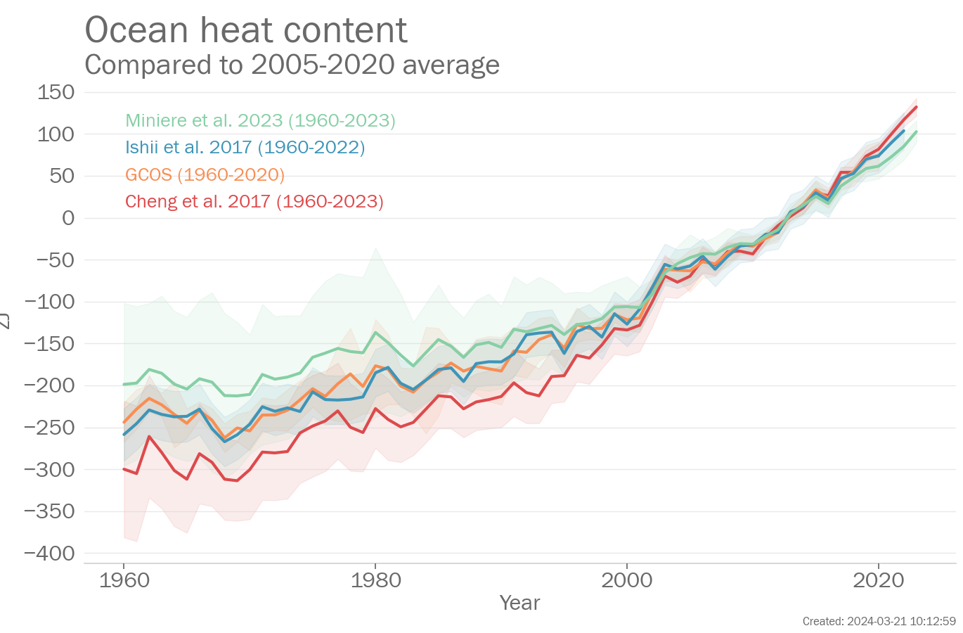
Global climate indicators (for an overview see Trewin et al. 2021) provide a broad view of climate change at the largest scale, encompassing the composition of the atmosphere, energy changes, and the responses of the land, ocean, and ice. These indicators are closely related to one another. For example, the rise in CO2 and other greenhouse gases in the atmosphere leads to an imbalance of energy and thus warming of the atmosphere and ocean. Warming of the ocean in turn leads to rising sea levels, to which is added the melting of ice on land in response to increasing atmospheric temperatures.
The global indicators draw on a wide range of data sets, which are listed at the bottom of the page. Differences between data sets for the same indicator indicate the degree of uncertainty in the indicator. Figures are updated at least annually, with some data sets being updated more frequently.
Under each of the figures, you will find links to the images in multiple file formats (png, pdf and svg), as well as a set of data as shown in the figure in a common comma-separated values (csv) format. The "Read more" link will take you to a wider range of linked indicators.
What the IPCC says
Regarding the large-scale changes in the climate, Working Group 1 from the sixth assessment report of the Intergovernmental Panel on Climate Change concluded that:
A.1 It is unequivocal that human influence has warmed the atmosphere, ocean and land. Widespread and rapid changes in the atmosphere, ocean, cryosphere and biosphere have occurred.
A.2 The scale of recent changes across the climate system as a whole - and the present state of many aspects of the climate system - are unprecedented over many centuries to many thousands of years.
A.3 Human-induced climate change is already affecting many weather and climate extremes in every region across the globe. Evidence of observed changes in extremes such as heatwaves, heavy precipitation, droughts, and tropical cyclones, and, in particular, their attribution to human influence, has strengthened since AR5.
Key messages
Global mean temperature
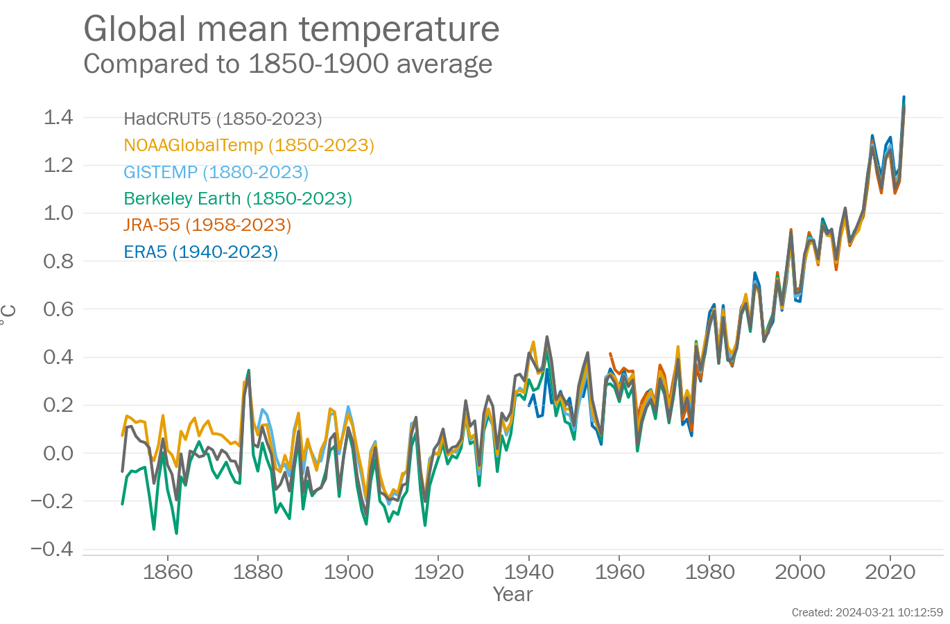
The year 2023 was ranked the 1st warmest on record. The anomaly for 2023 was 1.45 [1.32 to 1.57]°C relative to the 1850-1900 average 6 data sets were used in this assessment: Berkeley Earth, ERA5, GISTEMP, HadCRUT5, JRA-55, and NOAAGlobalTemp.
Paragraph updated: 2024-03-21 10:13
Global mean sea level
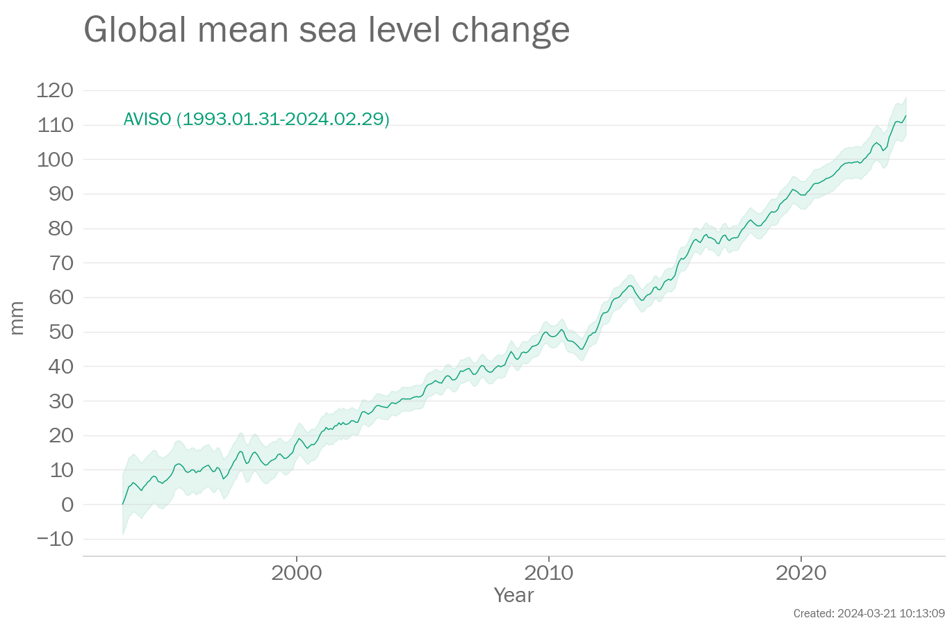
The rate of change in the AVISO data set is 3.4 mm/yr between 1993 and 2023.
Paragraph updated: 2024-03-21 10:13
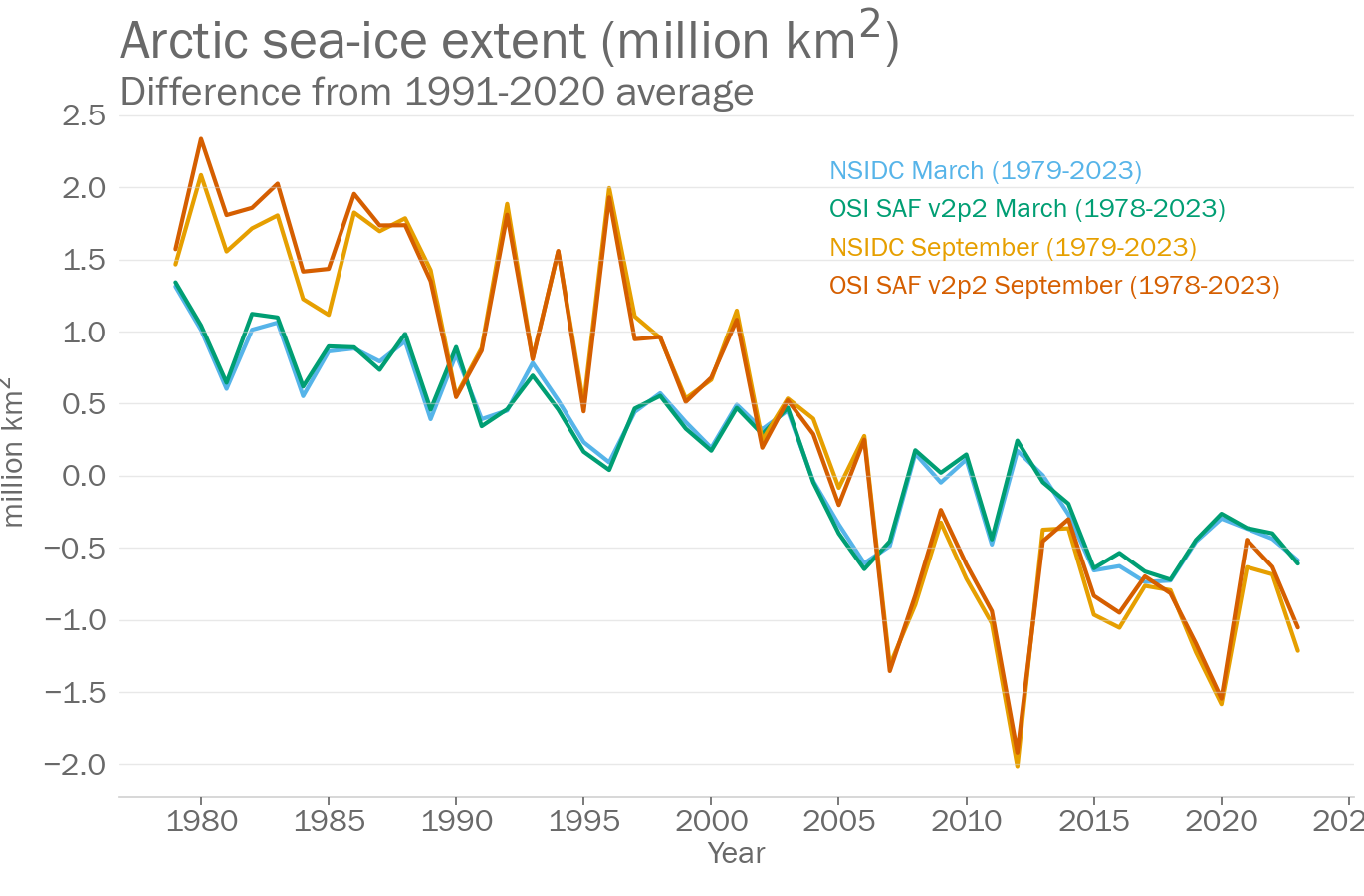
Arctic sea-ice extent
Arctic sea ice extent in March 2023 was between 14.42 and 14.44million km2. This was between the 5th and 6th lowest extent on record. In September the extent was between 4.37 and 4.86million km2. This was the 5th lowest extent on record. Data sets used were: NSIDC and OSI SAF v2.2
Paragraph updated: 2024-03-21 10:13
Dataset and processing details
Greenhouse gases
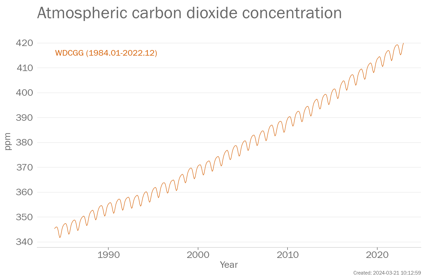
Carbon dioxide (CO2) is one of the most important greenhouse gases. The concentration of CO2 in the atmosphere is measured at stations around the world which are combined to provide a globally representative value.
The data in the above plot are available in a zip file containing a csv file for each data set.
Data file: Greenhouse_gases_data_files.zip
Checksum: 6590be7b2c988ac990391d8505511b0b
Format: BADC CSV format
WDCGG
Original data file (external link)
Citation:
To produce the plot, the following processing steps were performed:
- Data set created from file ['co2_monthly_20231115.csv'] downloaded from ['https://gaw.kishou.go.jp/static/publications/global_mean_mole_fractions/2023/co2_monthly_20231115.csv'] at ['2023-11-15 19:33:52']
Global temperature
Global mean temperature is based on measurements made at weather stations over land and by ships and buoys over the ocean. Temperatures are typically expressed as anomalies which are temperature differences from the average for a standard period. Here, 1850-1900 is used for the global mean. Instrumental temperature records are some of the longest climate records available, with some series extending back to the 17th century.
The data in the above plot are available in a zip file containing a csv file for each data set.
Data file: Global_temperature_data_files.zip
Checksum: 31a90d010c6f55baa9721f55b845ec9b
Format: BADC CSV format
Berkeley Earth
Original data file (external link)
Citation:
To produce the plot, the following processing steps were performed:
- Data set created from file ['Land_and_Ocean_complete.txt'] downloaded from ['https://berkeley-earth-temperature.s3.us-west-1.amazonaws.com/Global/Land_and_Ocean_complete.txt'] at ['2024-01-17 10:10:45']
- Rebaselined to 1981-2010 for each month separately by calculating the arithmetic mean of the data over the baseline period and subtracting the mean from all data values. This is done for each month separately (Januarys, Februarys etc).
- Calculated annual average from monthly averages using arithmetic mean
- Selected years within the range 1850 to 2023.
- Added offset of 0.69 to all data values.
- Manually changed baseline to 1850-1900. Note that data values remain unchanged.
ERA5
Original data file (external link)
Citation:
Data citation: Hersbach, H., Bell, B., Berrisford, P., Biavati, G., Horányi, A., Muñoz Sabater, J., Nicolas, J., Peubey, C., Radu, R., Rozum, I., Schepers, D., Simmons, A., Soci, C., Dee, D., Thépaut, J-N. (2023): ERA5 monthly averaged data on single levels from 1940 to present. Copernicus Climate Change Service (C3S) Climate Data Store (CDS), DOI: 10.24381/cds.f17050d7 (Accessed on 2024-01-05 08:43:31)
Acknowledgement: Contains using Copernicus Climate Change Service information [2024]. Neither the European Commission nor ECMWF is responsible for any use that may be made of the Copernicus information or data it contains.
To produce the plot, the following processing steps were performed:
- Data set created from file ['ts_1month_anomaly_Global_ERA5_2t_202312_1991-2020_v01.1.csv'] downloaded from ['https://climate.copernicus.eu/sites/default/files/ftp-data/temperature/2023/12/ERA5_1991-2020/ts_1month_anomaly_Global_ERA5_2t_202312_1991-2020_v01.1.csv'] at ['2024-01-05 08:43:31']
- Rebaselined to 1981-2010 for each month separately by calculating the arithmetic mean of the data over the baseline period and subtracting the mean from all data values. This is done for each month separately (Januarys, Februarys etc).
- Calculated annual average from monthly averages using arithmetic mean
- Selected years within the range 1850 to 2023.
- Added offset of 0.69 to all data values.
- Manually changed baseline to 1850-1900. Note that data values remain unchanged.
GISTEMP
Original data file (external link)
Citation:
Data citation: GISTEMP Team, 2022: GISS Surface Temperature Analysis (GISTEMP), version 4. NASA Goddard Institute for Space Studies. Dataset accessed 2024-01-06 11:31:29 at data.giss.nasa.gov/gistemp/.
To produce the plot, the following processing steps were performed:
- Data set created from file ['GLB.Ts+dSST.csv'] downloaded from ['https://data.giss.nasa.gov/gistemp/tabledata_v4/GLB.Ts+dSST.csv'] at ['2024-01-06 11:31:29']
- Rebaselined to 1981-2010 for each month separately by calculating the arithmetic mean of the data over the baseline period and subtracting the mean from all data values. This is done for each month separately (Januarys, Februarys etc).
- Calculated annual average from monthly averages using arithmetic mean
- Selected years within the range 1850 to 2023.
- Added offset of 0.69 to all data values.
- Manually changed baseline to 1850-1900. Note that data values remain unchanged.
HadCRUT5
Original data file (external link) Original data file (external link)
Citation:
Acknowledgement: HadCRUT.5.0.2.0 data were obtained from http://www.metoffice.gov.uk/hadobs/hadcrut5 on 2024-01-10 16:55:47 and are © British Crown Copyright, Met Office 2024, provided under an Open Government License, http://www.nationalarchives.gov.uk/doc/open-government-licence/version/3/
To produce the plot, the following processing steps were performed:
- Data set created from file ['HadCRUT.5.0.2.0.analysis.summary_series.global.monthly.csv', 'HadCRUT.5.0.2.0.analysis.summary_series.global.annual.csv'] downloaded from ['https://www.metoffice.gov.uk/hadobs/hadcrut5/data/HadCRUT.5.0.2.0/analysis/diagnostics/HadCRUT.5.0.2.0.analysis.summary_series.global.monthly.csv', 'https://www.metoffice.gov.uk/hadobs/hadcrut5/data/HadCRUT.5.0.2.0/analysis/diagnostics/HadCRUT.5.0.2.0.analysis.summary_series.global.annual.csv'] at ['2024-01-10 16:55:47', '2023-12-27 19:14:45']
- Rebaselined to 1981-2010 for each month separately by calculating the arithmetic mean of the data over the baseline period and subtracting the mean from all data values. This is done for each month separately (Januarys, Februarys etc).
- Calculated annual average from monthly averages using arithmetic mean
- Selected years within the range 1850 to 2023.
- Added offset of 0.69 to all data values.
- Manually changed baseline to 1850-1900. Note that data values remain unchanged.
JRA-55
Original data file (external link)
Citation:
To produce the plot, the following processing steps were performed:
- Data set created from file ['JRA-55_tmp2m_global_ts_Clim8110.txt'] downloaded from [''] at ['2024-01-05 11:44:00']
- Rebaselined to 1981-2010 for each month separately by calculating the arithmetic mean of the data over the baseline period and subtracting the mean from all data values. This is done for each month separately (Januarys, Februarys etc).
- Calculated annual average from monthly averages using arithmetic mean
- Selected years within the range 1850 to 2023.
- Added offset of 0.69 to all data values.
- Manually changed baseline to 1850-1900. Note that data values remain unchanged.
NOAAGlobalTemp
Original data file (external link) Original data file (external link)
Citation:
Data citation: R. S. Vose, B. Huang, X. Yin, D. Arndt, D. R. Easterling, J. H. Lawrimore, M. J. Menne, A. Sanchez-Lugo, and H. M. Zhang (2022): NOAA Global Surface Temperature Dataset (NOAAGlobalTemp), Version 5.1 [Global Mean]. NOAA National Centers for Environmental Information. doi.org/10.25921/2tj4-0e21 [2024-01-17 10:10:47].
To produce the plot, the following processing steps were performed:
- Data set created from file ['aravg.mon.land_ocean.90S.90N.v5.1.0.202312.asc', 'aravg.ann.land_ocean.90S.90N.*.asc'] downloaded from ['https://www.ncei.noaa.gov/data/noaa-global-surface-temperature/v5.1/access/timeseries/aravg.mon.land_ocean.90S.90N.v5.1.0.202312.asc', 'https://www.ncei.noaa.gov/data/noaa-global-surface-temperature/v5.1/access/timeseries/aravg.ann.land_ocean.90S.90N.*.asc'] at ['2024-01-17 10:10:47']
- Rebaselined to 1981-2010 for each month separately by calculating the arithmetic mean of the data over the baseline period and subtracting the mean from all data values. This is done for each month separately (Januarys, Februarys etc).
- Calculated annual average from monthly averages using arithmetic mean
- Selected years within the range 1850 to 2023.
- Added offset of 0.69 to all data values.
- Manually changed baseline to 1850-1900. Note that data values remain unchanged.
Ocean Indicators
The data in the above plot are available in a zip file containing a csv file for each data set.
Data file: Ocean_Indicators_data_files.zip
Checksum: d6f56bb86102a8b52708b46821db33e2
Format: BADC CSV format
Cheng et al. 2017
Original data file (external link)
Citation:
To produce the plot, the following processing steps were performed:
- Data set created from file ['gohc_wmo_state_climate_2024.nc'] downloaded from [''] at ['2024-02-27 13:18:00']
GCOS
Original data file (external link)
Citation:
Data citation: von Schuckmann, Karina; Minière, Audrey; Gues, Flora; Cuesta-Valero, Francisco; Kirchengast, Gottfried; Adusumilli, Susheel; Straneo, Fiammetta; Allan, Richard; Barker, Paul M.; Beltrami, Hugo; Boyer, Tim; Cheng, Lijing; Church, John; Desbruyeres, Damien; Dolman, Han; Domingues, Catia; García-García, Almudena; Giglio, Donata; Gilson, John; Gorfer, Maximilian; Haimberger, Leopold; Hendricks, Stefan; Hosoda, Shigeki; Johnson, Gregory; Killick, Rachel; King, Brian; Kolodziejczyk, Nicolas; Korosov, Anton; Krinner, Gerhard; Kuusela, Mikael; Langer, Moritz; Lavergne, Thomas; Li, Yuehua; Lyman, John; Marzeion, Ben; Mayer, Michael; MacDougall, Andrew; Lawrence, Isobel; McDougall, Trevor; Monselesan, Didier; Nitzbon, Jean; Otosaka, Inès; Peng, Jian; Purkey, Sarah; Roemmich, Dean; Sato, Kanako; Sato, Katsunari; Savita, Abhishek; Schweiger, Axel; Shepherd, Andrew; Seneviratne, Sonia; Simons, Leon; Slater, Donald; Slater, Thomas; Smith, Noah; Steiner, Andrea; Suga, Toshio; Szekely, Tanguy; Thiery, Wim; Timmermanns, Mary-Louise; Vanderkelen, Inne; Wijffels, Susan; Wu, Tonghua; Zemp, Michael (2022). Heat stored in the Earth system 1960-2020: Where does the energy go?. World Data Center for Climate (WDCC) at DKRZ. https://www.wdc-climate.de/ui/entry?acronym=GCOS_EHI_1960-2020
To produce the plot, the following processing steps were performed:
- Data set created from file ['gohc_wmo_state_climate_2024.nc'] downloaded from [''] at ['2024-02-27 13:18:00']
Ishii et al. 2017
Original data file (external link)
Citation:
To produce the plot, the following processing steps were performed:
- Data set created from file ['gohc_wmo_state_climate_2024.nc'] downloaded from [''] at ['2024-02-27 13:18:00']
Miniere et al. 2023
Original data file (external link)
Citation:
To produce the plot, the following processing steps were performed:
- Data set created from file ['gohc_wmo_state_climate_2024.nc'] downloaded from [''] at ['2024-02-27 13:18:00']
Sea level
Global mean sea level is a measured by satellites using radar altimeters that record the time taken for a radar signal to reach the sea-surface and return to the satellite. Longer records of sea level (not shown here) exist based on tide gauge measurements made along coastlines around the world since the late 19th century.
The data in the above plot are available in a zip file containing a csv file for each data set.
Data file: Sea_level_data_files.zip
Checksum: 4f378ca803be5f1ca49602f579e602b6
Format: BADC CSV format
AVISO
Original data file (external link)
Citation:
Acknowledgement: Generated using AVISO+ Products
To produce the plot, the following processing steps were performed:
- Data set created from file ['reprocessed_gmsl_data29022024.csv'] downloaded from [''] at ['2024-03-21 09:46:40']
Sea ice
Sea-ice concentrations are estimated from microwave radiances measured from satellites (from 1979). Sea-ice extent is calculated as the area of ocean grid cells where the sea-ice concentration exceeds 15%. Although there are relatively large differences in the absolute extent between data sets, they agree well on the year-to-year changes and the trends.
The data in the above plot are available in a zip file containing a csv file for each data set.
Data file: Sea_ice_data_files.zip
Checksum: 5b29316387f79a5fba80685f9803cb2e
Format: BADC CSV format
NSIDC
Original data file (external link) Original data file (external link) Original data file (external link) Original data file (external link) Original data file (external link) Original data file (external link) Original data file (external link) Original data file (external link) Original data file (external link) Original data file (external link) Original data file (external link) Original data file (external link)
Data citation: Fetterer, F., K. Knowles, W. N. Meier, M. Savoie, and A. K. Windnagel. 2017, updated daily. Sea Ice Index, Version 3. 1979-present. Boulder, Colorado USA. NSIDC: National Snow and Ice Data Center. doi: https://doi.org/10.7265/N5K072F8. [2024-02-21 17:08:08].
Acknowledgement: Fetterer, F., K. Knowles, W. N. Meier, M. Savoie, and A. K. Windnagel. 2017, updated daily. Sea Ice Index, Version 3. 1979-present. Boulder, Colorado USA. NSIDC: National Snow and Ice Data Center. doi: https://doi.org/10.7265/N5K072F8. [2024-02-21 17:08:08].
To produce the plot, the following processing steps were performed:
- Data set created from file ['N_01_extent_v3.0.csv', 'N_02_extent_v3.0.csv', 'N_03_extent_v3.0.csv', 'N_04_extent_v3.0.csv', 'N_05_extent_v3.0.csv', 'N_06_extent_v3.0.csv', 'N_07_extent_v3.0.csv', 'N_08_extent_v3.0.csv', 'N_09_extent_v3.0.csv', 'N_10_extent_v3.0.csv', 'N_11_extent_v3.0.csv', 'N_12_extent_v3.0.csv'] downloaded from ['ftp://sidads.colorado.edu/DATASETS/NOAA/G02135/north/monthly/data/N_01_extent_v3.0.csv', 'ftp://sidads.colorado.edu/DATASETS/NOAA/G02135/north/monthly/data/N_02_extent_v3.0.csv', 'ftp://sidads.colorado.edu/DATASETS/NOAA/G02135/north/monthly/data/N_03_extent_v3.0.csv', 'ftp://sidads.colorado.edu/DATASETS/NOAA/G02135/north/monthly/data/N_04_extent_v3.0.csv', 'ftp://sidads.colorado.edu/DATASETS/NOAA/G02135/north/monthly/data/N_05_extent_v3.0.csv', 'ftp://sidads.colorado.edu/DATASETS/NOAA/G02135/north/monthly/data/N_06_extent_v3.0.csv', 'ftp://sidads.colorado.edu/DATASETS/NOAA/G02135/north/monthly/data/N_07_extent_v3.0.csv', 'ftp://sidads.colorado.edu/DATASETS/NOAA/G02135/north/monthly/data/N_08_extent_v3.0.csv', 'ftp://sidads.colorado.edu/DATASETS/NOAA/G02135/north/monthly/data/N_09_extent_v3.0.csv', 'ftp://sidads.colorado.edu/DATASETS/NOAA/G02135/north/monthly/data/N_10_extent_v3.0.csv', 'ftp://sidads.colorado.edu/DATASETS/NOAA/G02135/north/monthly/data/N_11_extent_v3.0.csv', 'ftp://sidads.colorado.edu/DATASETS/NOAA/G02135/north/monthly/data/N_12_extent_v3.0.csv'] at ['2024-02-21 17:08:08', '2024-02-21 17:08:09', '2024-02-21 17:08:10', '2024-02-21 17:08:11', '2024-02-21 17:08:13', '2024-02-21 17:08:14', '2024-02-21 17:08:15', '2024-02-21 17:08:16', '2024-02-21 17:08:17', '2024-02-21 17:08:18', '2024-02-21 17:08:19', '2024-02-21 17:08:20']
- Rebaselined to 1991-2020 for each month separately by calculating the arithmetic mean of the data over the baseline period and subtracting the mean from all data values. This is done for each month separately (Januarys, Februarys etc).
- Calculated annual series by extracting March from each year
- Calculated annual series by extracting September from each year
OSI SAF v2.2
Original data file (external link)
Citation:
Data citation: EUMETSAT Ocean and Sea Ice Satellite Application Facility, Sea ice index 1979-onwards (v2.1, 2020), OSI-420, Data extracted from OSI SAF FTP server: 1979-present, Northern Hemisphere, accessed 2024-02-21 17:08:24
Acknowledgement: The OSI SAF Sea Ice Index v2.2 is made available at https://osisaf-hl.met.no/v2p1-sea-ice-index. The OSI SAF Sea Ice Index v2p1 is prepared using EUMETSAT OSI SAF Sea Ice Concentration data, with R&D input from the ESA Climate Change Initiative (ESA CCI) (Lavergne et al. 2019)
To produce the plot, the following processing steps were performed:
- Data set created from file ['osisaf_nh_sie_monthly.txt'] downloaded from ['ftp://osisaf.met.no/prod_test/ice/index/v2p2/nh/osisaf_nh_sie_monthly.txt'] at ['2024-02-21 17:08:24']
- Rebaselined to 1991-2020 for each month separately by calculating the arithmetic mean of the data over the baseline period and subtracting the mean from all data values. This is done for each month separately (Januarys, Februarys etc).
- Calculated annual series by extracting March from each year
- Calculated annual series by extracting September from each year
Glaciers
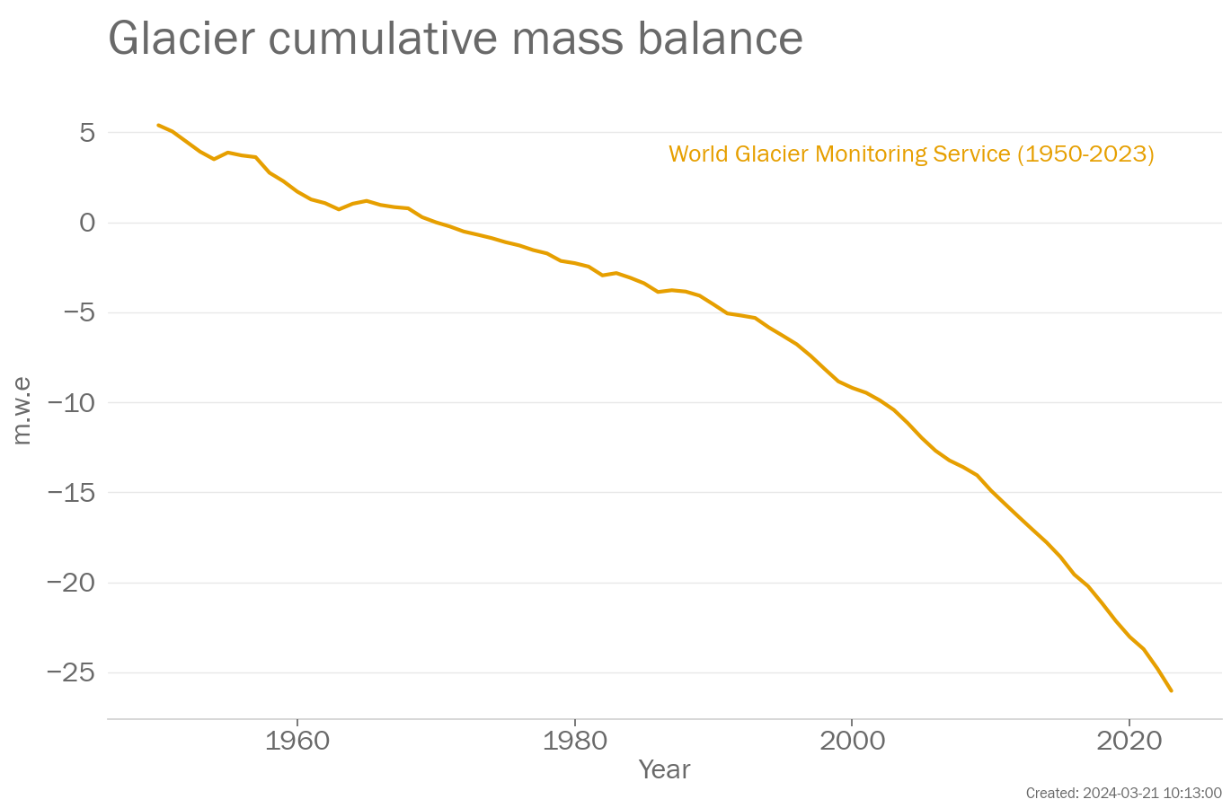
Glaciers are measured using a variety of different techniques. Glacier mass balance data for the global network of reference glaciers are available from the World Glacier Monitoring Service (WGMS), https://www.wgms.ch.
The data in the above plot are available in a zip file containing a csv file for each data set.
Data file: Glaciers_data_files.zip
Checksum: d3996fecd971e7adca130a8eec3f5e66
Format: BADC CSV format
World Glacier Monitoring Service
Original data file (external link)
Citation:
Data citation: WGMS (2017, updated, and earlier reports): Global Glacier Change Bulletin No. 2 (2014-2015). Zemp, M., Nussbaumer, S. U., Gärtner-Roer, I., Huber, J., Machguth, H., Paul, F., and Hoelzle, M. (eds.), ICSU(WDS)/IUGG(IACS)/UNEP/UNESCO/WMO, World Glacier Monitoring Service, Zurich, Switzerland, 244 pp., based on database version: doi:10.5904/wgms-fog-2018-11.
To produce the plot, the following processing steps were performed:
- Data set created from file ['mb_ref.csv'] downloaded from ['http://wgms.ch/data/faq/mb_ref.csv'] at ['2024-02-12 14:12:31']
Greenland ice sheet
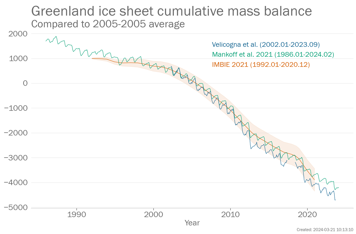
The Greenland ice sheet mass balance measures the change in ice mass of the Greenland ice sheet. The change in mass is estimated in three principle ways: gravimetric measurements, altimetric measurements and the input-output method. Gravimetric measurements infer mass changes from variations in the Earth's gravitational field as measured by the GRACE and GRACE-FO (Gravity Recovery and Climate Experiment - Follow On) satellites. Altimetric measurements, measured the height of the ice sheet surface, using radar and laser altimeters. Input-output methods, use weather conditions from a numerical weather prediction model, to estimate changes in mass balance at the surface of the ice sheet. These are combined with estimates of mass loss from glaciers around the edge of Greenland and melting on the underside of the glaciers. The IMBIE data set combines over 25 different estimates of Greenland mass balance to get a comprehensive view of the long-term changes.
The data in the above plot are available in a zip file containing a csv file for each data set.
Data file: Greenland_ice_sheet_data_files.zip
Checksum: 2f7a8d9ffe728fc5a9ed2f2e974eba08
Format: BADC CSV format
IMBIE 2021
Original data file (external link)
Citation:
Data citation: Shepherd, A., Ivins, E., Rignot, E., Smith, B., van den Broeke, M., Velicogna, I., Whitehouse, P., Briggs, K., Joughin, I., Krinner, G., Nowicki, S., Payne, A., Scambos, T., Schlegel, N., A, G., Agosta, C., Ahlstrøm, A., Babonis, G., Barletta, V., … Wuite, J. (2021). Antarctic and Greenland Ice Sheet mass balance 1992-2020 for IPCC AR6 (Version 1.0) [Data set]. UK Polar Data Centre, Natural Environment Research Council, UK Research & Innovation. https://doi.org/10.5285/77B64C55-7166-4A06-9DEF-2E400398E452
To produce the plot, the following processing steps were performed:
- Data set created from file ['imbie_greenland_2021_Gt.csv'] downloaded from ['https://ramadda.data.bas.ac.uk/repository/entry/get/imbie_greenland_2021_Gt.csv?entryid=synth%3A77b64c55-7166-4a06-9def-2e400398e452%3AL2ltYmllX2dyZWVubGFuZF8yMDIxX0d0LmNzdg%3D%3D'] at ['2023-08-07 14:40:20']
- Zeroed series on July 2005 by subtracting the value for that month from all data values (see next entry)
- Added offset of 1000.3866 to all data values.
- Manually changed baseline to 2005-2005. Note that data values remain unchanged.
Velicogna et al.
Original data file (external link)
Citations:
- Geruo, A., Wahr, J., & Zhong, S. (2013). Computations of the viscoelastic response of a 3-D compressible Earth to surface loading: An application to Glacial Isostatic Adjustment in Antarctica and Canada. Geophysical Journal International, 192(2), 557–572.
- Ivins, E. R., T. S. James, J. Wahr, E. J. O Schrama, F. W. Landerer, and K. M. Simon (2013), Antarctic contribution to sea level rise observed by GRACE with improved GIA correction, J. Geophys. Res. Solid Earth, 118, 3126–3141, doi:10.1002/jgrb.50208.
- Loomis, B. D., Rachlin, K. E., & Luthcke, S. B. (2019). Improved Earth oblateness rate reveals increased ice sheet losses and mass-driven sea level rise. Geophysical Research Letters, 46, 6910–6917. https://doi.org/10.1029/2019GL082929.
- Peltier, W., Argus, D., & Drummond, R. (2015). Space geodesy constrains ice age terminal deglaciation: The global ICE-6G_C (VM5a) model. Journal of Geophysical Research: Solid Earth, 120, 450–487. https://doi.org/10.1002/2014JB011176.
- Simpson, M. J., Milne, G. A., Huybrechts, P., & Long, A. J. (2009). Calibrating a glaciological model of the Greenland ice sheet from the Last Glacial Maximum to present-day using field observations of relative sea level and ice extent. Quaternary Science Reviews, 28(17), 1631–1657.
- Sutterley, T. C., & Velicogna, I. (2019). Improved estimates of geocenter variability from time-variable gravity and ocean model outputs. Remote Sensing, 11(18), 2108.
- Velicogna I., Mohajerani Y., A G., Landerer F., Mouginot J., Noel B., Rignot E., Sutterley T., van den Broeke M., van Wessem J., Wiese D. (2020). Continuity of ice sheet mass loss in Greenland and Antarctica from the GRACE and GRACE Follow-On missions, Geophys. Res. Lett. 47, e2020GL087291.
Notes: Gravimetric (GRACE) ice mass time series for the Greenland and Antarctic Ice Sheets are calculated using spherical harmonics from JPL RL06v1, following Velicogna et al (2020). The degree-1 geocentre terms are calculated using Sutterley and Velicogna (2019), using Loomis et al (2020) C2.0 and C3.0 coefficients. The GRACE/GRACE-FO data are corrected for the long-term trend of glacial isostatic adjustment (GIA) from the solid earth using the regional IJ05 R2 GIA model (Ivins et al., 2013) over Antarctica and the regional Simpson et al. (2009) GIA model over Greenland. These regional GIA models do not include realistic GIA signal outside the ice sheets. For this reason, outside of Greenland and Antarctica, GIA corrections are based on Geruou et al. (2013) with the ICE6G ice history (Peltier et al., 2015).
To produce the plot, the following processing steps were performed:
- Data set created from file ['out_ts_filled_4_261_GIS.txt'] downloaded from [''] at ['2024-02-28 15:05:54']
- Zeroed series on July 2005 by subtracting the value for that month from all data values (see next entry)
- Added offset of -1982.552 to all data values.
- Manually changed baseline to 2005-2005. Note that data values remain unchanged.
Antarctic ice sheet
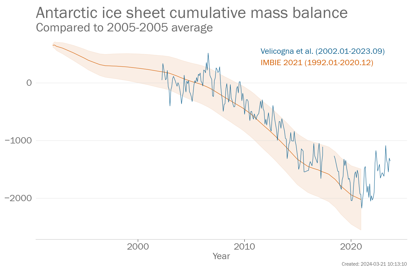
The Antarctic ice sheet mass balance measures the change in ice mass of the Antarctic ice sheet. The change in mass is estimated in three principle ways: gravimetric measurements, altimetric measurements and the input-output method. Gravimetric measurements infer mass changes from variations in the Earth's gravitational field as measured by the GRACE and GRACE-FO (Gravity Recovery and Climate Experiment - Follow On) satellites. Altimetric measurements, measured the height of the ice sheet surface, using radar and laser altimeters. Input-output methods, use weather conditions from a numerical weather prediction model, to estimate changes in mass balance at the surface of the ice sheet. These are combined with estimates of mass loss from glaciers around the edge of the continent and melting on the underside of the glaciers. The IMBIE data set combines many estimates of Antarctic mass balance to get a comprehensive view of the long-term changes.
The data in the above plot are available in a zip file containing a csv file for each data set.
Data file: Antarctic_ice_sheet_data_files.zip
Checksum: f6705543298cf13190108b80ec4e5be3
Format: BADC CSV format
IMBIE 2021
Original data file (external link)
Citation:
Data citation: Shepherd, A., Ivins, E., Rignot, E., Smith, B., van den Broeke, M., Velicogna, I., Whitehouse, P., Briggs, K., Joughin, I., Krinner, G., Nowicki, S., Payne, A., Scambos, T., Schlegel, N., A, G., Agosta, C., Ahlstrøm, A., Babonis, G., Barletta, V., … Wuite, J. (2021). Antarctic and Greenland Ice Sheet mass balance 1992-2020 for IPCC AR6 (Version 1.0) [Data set]. UK Polar Data Centre, Natural Environment Research Council, UK Research & Innovation. https://doi.org/10.5285/77B64C55-7166-4A06-9DEF-2E400398E452
To produce the plot, the following processing steps were performed:
- Data set created from file ['imbie_antarctica_2021_Gt.csv'] downloaded from ['https://ramadda.data.bas.ac.uk/repository/entry/get/imbie_antarctica_2021_Gt.csv?entryid=synth%3A77b64c55-7166-4a06-9def-2e400398e452%3AL2ltYmllX2FudGFyY3RpY2FfMjAyMV9HdC5jc3Y%3D'] at ['2023-08-07 14:40:19']
- Zeroed series on June 2005 by subtracting the value for that month from all data values (see next entry)
- Added offset of 646.1411 to all data values.
- Manually changed baseline to 2005-2005. Note that data values remain unchanged.
Velicogna et al.
Original data file (external link)
Citations:
- Geruo, A., Wahr, J., & Zhong, S. (2013). Computations of the viscoelastic response of a 3-D compressible Earth to surface loading: An application to Glacial Isostatic Adjustment in Antarctica and Canada. Geophysical Journal International, 192(2), 557–572.
- Ivins, E. R., T. S. James, J. Wahr, E. J. O Schrama, F. W. Landerer, and K. M. Simon (2013), Antarctic contribution to sea level rise observed by GRACE with improved GIA correction, J. Geophys. Res. Solid Earth, 118, 3126–3141, doi:10.1002/jgrb.50208.
- Loomis, B. D., Rachlin, K. E., & Luthcke, S. B. (2019). Improved Earth oblateness rate reveals increased ice sheet losses and mass-driven sea level rise. Geophysical Research Letters, 46, 6910–6917. https://doi.org/10.1029/2019GL082929.
- Peltier, W., Argus, D., & Drummond, R. (2015). Space geodesy constrains ice age terminal deglaciation: The global ICE-6G_C (VM5a) model. Journal of Geophysical Research: Solid Earth, 120, 450–487. https://doi.org/10.1002/2014JB011176.
- Simpson, M. J., Milne, G. A., Huybrechts, P., & Long, A. J. (2009). Calibrating a glaciological model of the Greenland ice sheet from the Last Glacial Maximum to present-day using field observations of relative sea level and ice extent. Quaternary Science Reviews, 28(17), 1631–1657.
- Sutterley, T. C., & Velicogna, I. (2019). Improved estimates of geocenter variability from time-variable gravity and ocean model outputs. Remote Sensing, 11(18), 2108.
- Velicogna I., Mohajerani Y., A G., Landerer F., Mouginot J., Noel B., Rignot E., Sutterley T., van den Broeke M., van Wessem J., Wiese D. (2020). Continuity of ice sheet mass loss in Greenland and Antarctica from the GRACE and GRACE Follow-On missions, Geophys. Res. Lett. 47, e2020GL087291.
Notes: Gravimetric (GRACE) ice mass time series for the Greenland and Antarctic Ice Sheets are calculated using spherical harmonics from JPL RL06v1, following Velicogna et al (2020). The degree-1 geocentre terms are calculated using Sutterley and Velicogna (2019), using Loomis et al (2020) C2.0 and C3.0 coefficients. The GRACE/GRACE-FO data are corrected for the long-term trend of glacial isostatic adjustment (GIA) from the solid earth using the regional IJ05 R2 GIA model (Ivins et al., 2013) over Antarctica and the regional Simpson et al. (2009) GIA model over Greenland. These regional GIA models do not include realistic GIA signal outside the ice sheets. For this reason, outside of Greenland and Antarctica, GIA corrections are based on Geruou et al. (2013) with the ICE6G ice history (Peltier et al., 2015).
To produce the plot, the following processing steps were performed:
- Data set created from file ['out_ts_filled_4_261_AIS.txt'] downloaded from [''] at ['2024-02-28 15:05:42']
- Zeroed series on June 2005 by subtracting the value for that month from all data values (see next entry)
- Added offset of -761.983 to all data values.
- Manually changed baseline to 2005-2005. Note that data values remain unchanged.
Precipitation
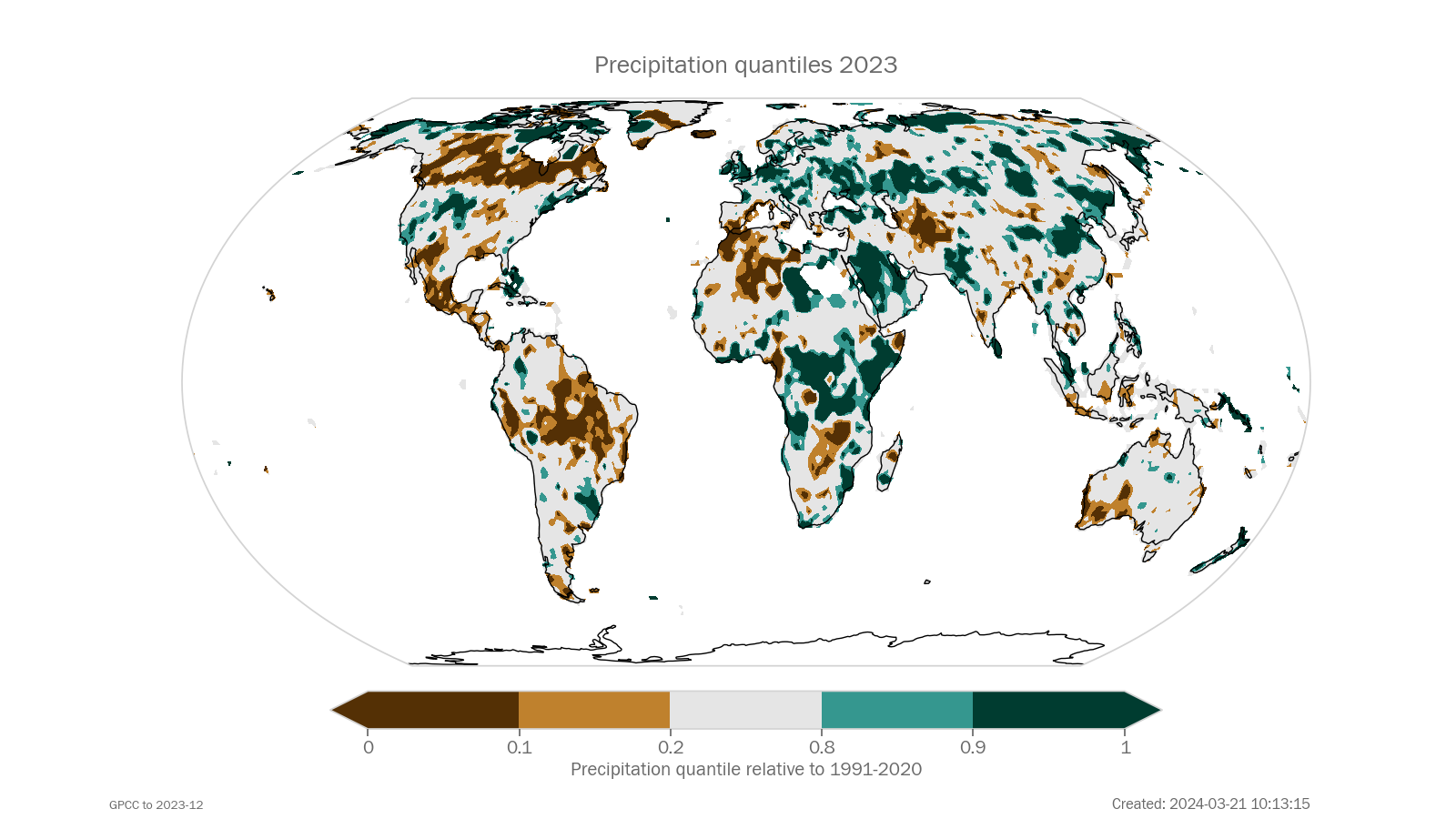
Precipitation quantiles are based on the twelve months aggregated GPCC Monitoring Product and First Guess Monthly product. The baseline period is 1991-2020, using Full Data Monthly in its latest version. Quality controlled rain gauge (in situ) data are used and the quality control protocol depends on the data set. The percentiles are not calculated for those grid cells, where the precipitation total aggregated in the reference period is below ten millimetres.
The data in the above plot are available in a zip file containing a csv file for each data set.
Data file: Precipitation_data_files.zip
Checksum: 76cdb2bad9582d23c1f6f4d868218d6c
Format: BADC CSV format
GPCC
Original data file (external link)
To produce the plot, the following processing steps were performed:
- Gridded dataset created from file ['gpcc_quantile_12month_*-YYYYMMMM.nc.gz'] downloaded from ['https://opendata.dwd.de/climate_environment/GPCC/GPCC_Quantile/Last12Month/gpcc_quantile_12month_*-YYYYMMMM.nc.gz']
- Selected single month 12/2023
Short-term Climate Drivers
The data in the above plot are available in a zip file containing a csv file for each data set.
Data file: Short-term_Climate_Drivers_data_files.zip
Checksum: eca7e1083e822793f442830e3ce69a6b
Format: BADC CSV format
ERSSTv5
Original data file (external link)
To produce the plot, the following processing steps were performed:
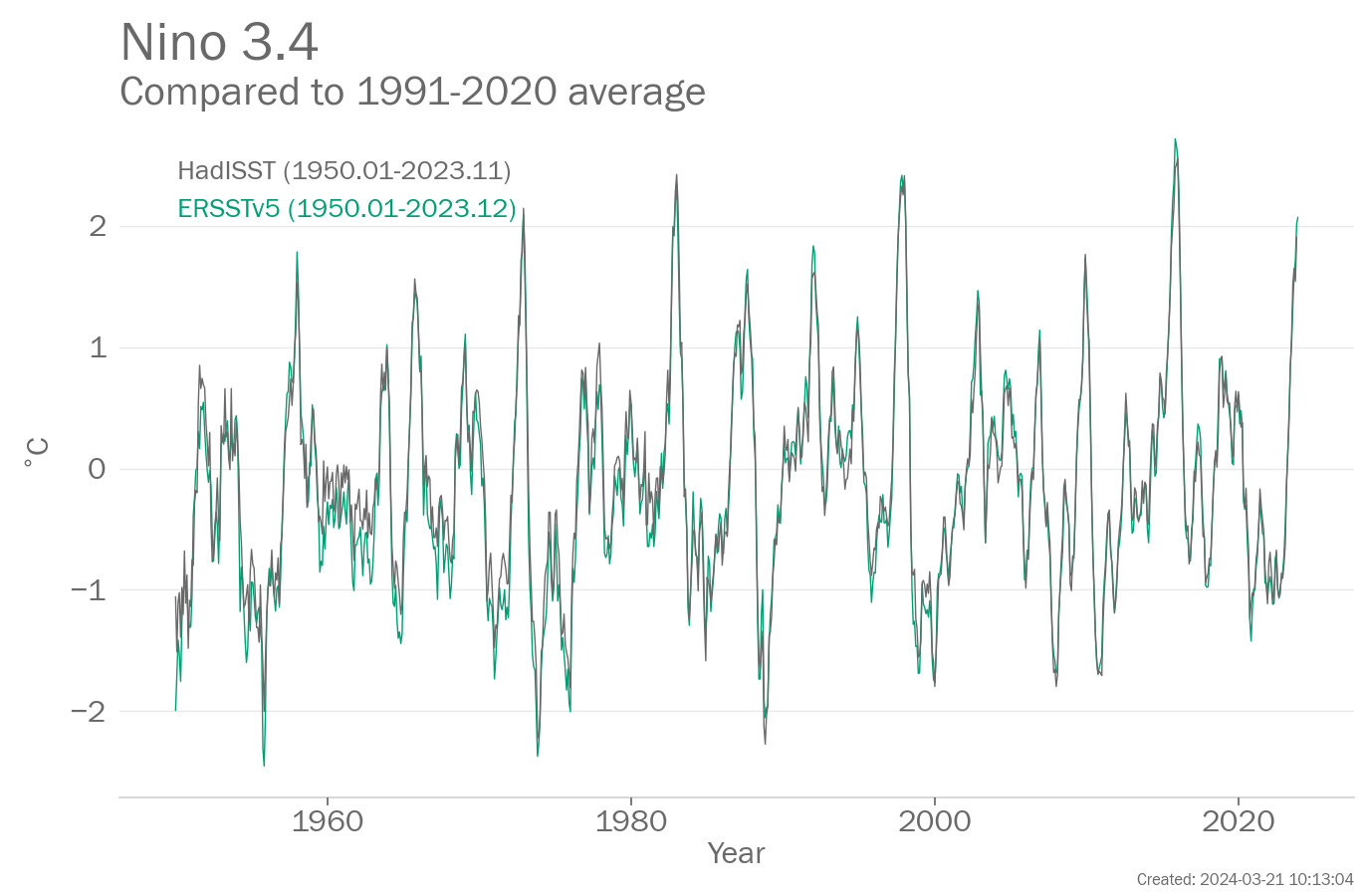
- Data set created from file ['nina34.data'] downloaded from ['https://psl.noaa.gov/data/correlation/nina34.data'] at ['2024-01-16 13:55:43']
- Rebaselined to 1991-2020 for each month separately by calculating the arithmetic mean of the data over the baseline period and subtracting the mean from all data values. This is done for each month separately (Januarys, Februarys etc).
- Selected years within the range 1950 to 2023.
HadISST
Original data file (external link)
To produce the plot, the following processing steps were performed:
- Data set created from file ['nino34.long.data'] downloaded from ['https://psl.noaa.gov/gcos_wgsp/Timeseries/Data/nino34.long.data'] at ['2024-01-16 13:55:44']
- Rebaselined to 1991-2020 for each month separately by calculating the arithmetic mean of the data over the baseline period and subtracting the mean from all data values. This is done for each month separately (Januarys, Februarys etc).
- Selected years within the range 1950 to 2023.
Page created on 2024-03-21 using climind v1.0