Ocean Indicators

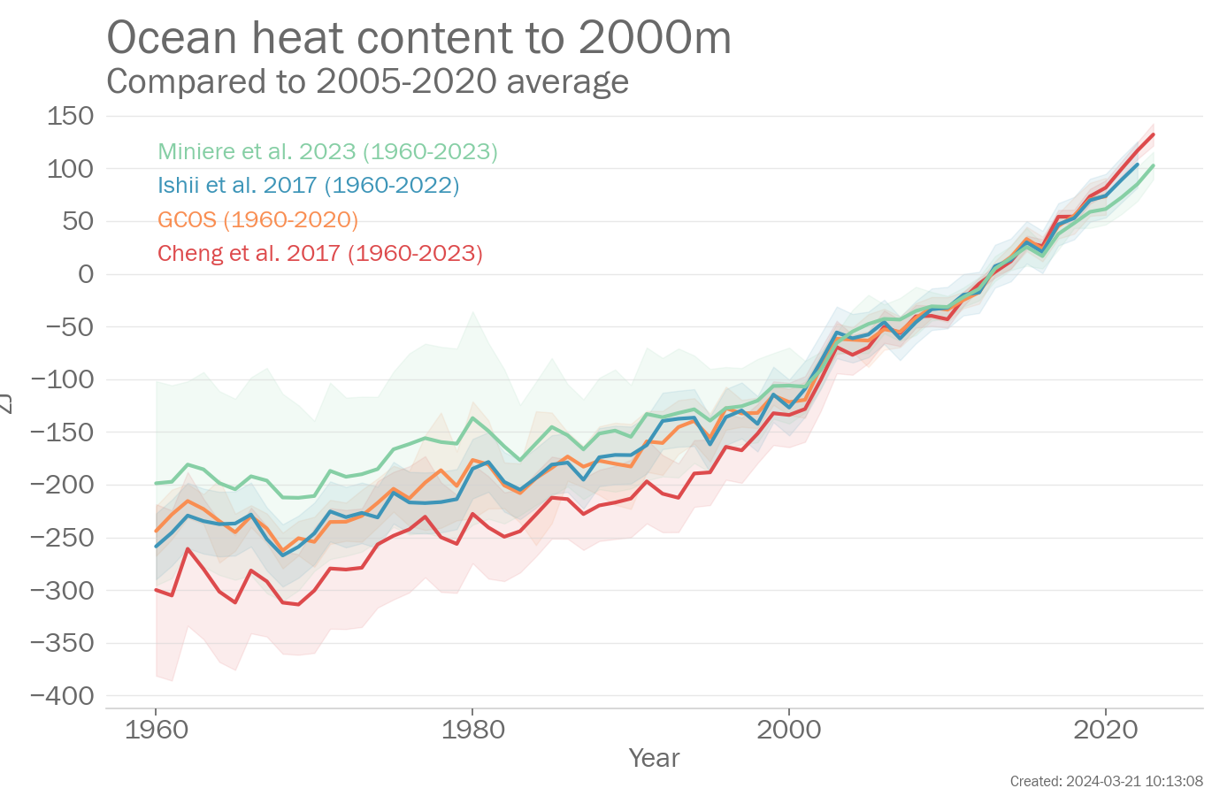
Ocean heat content to 2000m
Annual Global ocean heat content (zJ, difference from the 2005-2020 average) from 1960-2023. Data are from the following four data sets: Cheng et al. 2017, GCOS, Ishii et al. 2017, Miniere et al. 2023.
Introduction
The ocean covers nearly 70% of the Earth's surface. Most of the excess energy that accumulates in the Earth system due to increasing concentrations of greenhouse gases is taken up by the ocean. The added energy warms the ocean and this warming causes the water to expand, which in turn leads to sea-level rise. The melting of ice on the land also adds to sea level rise. The surface layers of the ocean have warmed more rapidly than the deeper interior, mirrored in the rise of global mean sea-surface temperature and in the increased incidence of marine heatwaves.
As the concentration of CO2 in the atmosphere increases, so too does the concentration of CO2 in the ocean. This affects ocean chemistry, lowering the average pH of the water, a process known as ocean acidification, though it should be noted that the ocean remains, on average, slightly alkaline. All these changes have a broad range of impacts and interactions in the ocean and coastal areas.
What the IPCC says
A1.6 It is virtually certain that the global upper ocean (0-700 m) has warmed since the 1970s and extremely likely that human influence is the main driver. It is virtually certain that human-caused CO2 emissions are the main driver of current global acidification of the surface open ocean. There is high confidence that oxygen levels have dropped in many upper ocean regions since the mid-20th century and medium confidence that human influence contributed to this drop.
A1.7 Global mean sea level increased by 0.20 [0.15 to 0.25] m between 1901 and 2018. The average rate of sea level rise was 1.3 [0.6 to 2.1] mm.yr-1 between 1901 and 1971, increasing to 1.9 [0.8 to 2.9] mm.yr-1 between 1971 and 2006, and further increasing to 3.7 [3.2 to 4.2] mm.yr-1 between 2006 and 2018 (high confidence). Human influence was very likely the main driver of these increases since at least 1971.
Chapter 2 Ocean pH has declined globally at the surface over the past four decades (virtually certain) and in all ocean basins in the ocean interior (high confidence) over the past 2-3 decades. A long-term increase in surface open ocean pH occurred over the past 50 million years (high confidence), and surface ocean pH as low as recent times is uncommon in the last 2 million years (medium confidence)
Chapter 9 Since the 1980s [marine heatwaves] have also become more intense and longer. Satellite observations and reanalyses of SST show an increase in intensity of 0.04°C per decade from 1982 to 2016, an increase in spatial extent of 19% per decade from 1982 to 2016, and an increase in annual MHW days of 54% between the 1987-2016 period compared to 1925-1954. The SROCC assessed that 84-90% of all MHWs that occurred between 2006 and 2015 are very likely caused by anthropogenic warming. There is new evidence since SROCC that the frequency of the most impactful marine heatwaves over the last few decades has increased more than 20-fold because of anthropogenic global warming. In summary, there is high confidence that MHWs have increased in frequency over the 20th century, with an approximate doubling from 1982 to 2016, and medium confidence that they have become more intense and longer since the 1980s
Key messages
Global ocean heat content
The year 2023 was ranked the 1st highest on record. The mean value for 2023 was 117.38zJ relative to the 2005-2020 average (102.64-132.11zJ depending on the data set used). 2 data sets were used in this assessment: Cheng et al. 2017 and Miniere et al. 2023.
The year 2022 was ranked the 2nd highest on record. The mean value for 2022 was 100.96zJ relative to the 2005-2020 average (85.10-116.82zJ depending on the data set used). 2 data sets were used in this assessment: Cheng et al. 2017 and Miniere et al. 2023.
Paragraph updated: 2024-03-21 10:13
Global ocean area affected by marine heatwaves
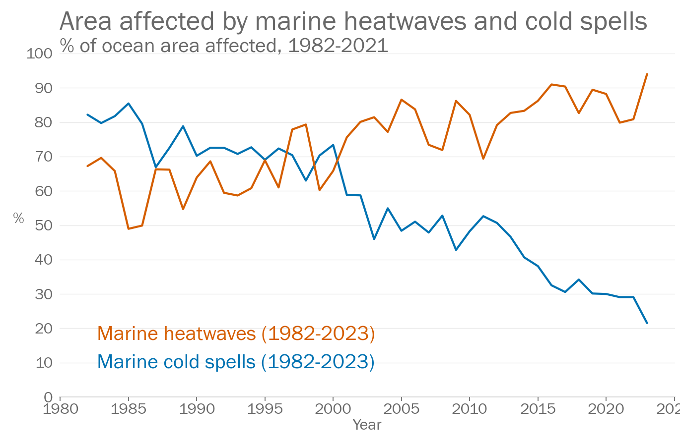
In 2023, 94.0% of the ocean was affected by at least one marine heatwave. The 1st highest on record. The highest ocean area affected in any year was 94.0% in 2023.
Paragraph updated: 2024-03-21 10:13
Global ocean area affected by marine cold spells
The area of the ocean affected by at least one marine cold spells was 21.5%. The 42nd highest on record. The highest area affected in any year by marine cold spells was 85.5% in 1985.
Paragraph updated: 2024-03-21 10:13
Dataset and processing details
Ocean heat content to 2000m
The data in the above plot are available in a zip file containing a csv file for each data set.
Data file: Ocean_heat_content_to_2000m_data_files.zip
Checksum: 094508daa167f21a3ff838af75f56c73
Format: BADC CSV format
Cheng et al. 2017
Original data file (external link)
Citation:
To produce the plot, the following processing steps were performed:
- Data set created from file ['gohc_wmo_state_climate_2024.nc'] downloaded from [''] at ['2024-02-27 13:18:00']
GCOS
Original data file (external link)
Citation:
Data citation: von Schuckmann, Karina; Minière, Audrey; Gues, Flora; Cuesta-Valero, Francisco; Kirchengast, Gottfried; Adusumilli, Susheel; Straneo, Fiammetta; Allan, Richard; Barker, Paul M.; Beltrami, Hugo; Boyer, Tim; Cheng, Lijing; Church, John; Desbruyeres, Damien; Dolman, Han; Domingues, Catia; García-García, Almudena; Giglio, Donata; Gilson, John; Gorfer, Maximilian; Haimberger, Leopold; Hendricks, Stefan; Hosoda, Shigeki; Johnson, Gregory; Killick, Rachel; King, Brian; Kolodziejczyk, Nicolas; Korosov, Anton; Krinner, Gerhard; Kuusela, Mikael; Langer, Moritz; Lavergne, Thomas; Li, Yuehua; Lyman, John; Marzeion, Ben; Mayer, Michael; MacDougall, Andrew; Lawrence, Isobel; McDougall, Trevor; Monselesan, Didier; Nitzbon, Jean; Otosaka, Inès; Peng, Jian; Purkey, Sarah; Roemmich, Dean; Sato, Kanako; Sato, Katsunari; Savita, Abhishek; Schweiger, Axel; Shepherd, Andrew; Seneviratne, Sonia; Simons, Leon; Slater, Donald; Slater, Thomas; Smith, Noah; Steiner, Andrea; Suga, Toshio; Szekely, Tanguy; Thiery, Wim; Timmermanns, Mary-Louise; Vanderkelen, Inne; Wijffels, Susan; Wu, Tonghua; Zemp, Michael (2022). Heat stored in the Earth system 1960-2020: Where does the energy go?. World Data Center for Climate (WDCC) at DKRZ. https://www.wdc-climate.de/ui/entry?acronym=GCOS_EHI_1960-2020
To produce the plot, the following processing steps were performed:
- Data set created from file ['gohc_wmo_state_climate_2024.nc'] downloaded from [''] at ['2024-02-27 13:18:00']
Ishii et al. 2017
Original data file (external link)
Citation:
To produce the plot, the following processing steps were performed:
- Data set created from file ['gohc_wmo_state_climate_2024.nc'] downloaded from [''] at ['2024-02-27 13:18:00']
Miniere et al. 2023
Original data file (external link)
Citation:
To produce the plot, the following processing steps were performed:
- Data set created from file ['gohc_wmo_state_climate_2024.nc'] downloaded from [''] at ['2024-02-27 13:18:00']
Ocean pH
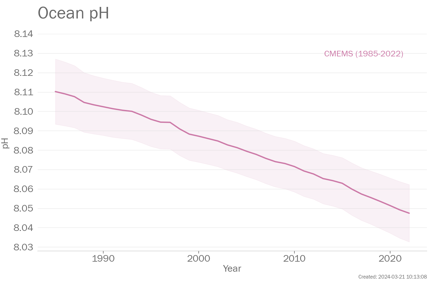
Ocean pH is a measure of how acid/alkaline the ocean surface water is. The ocean surface is typically slightly alkaline, however, increasing concentration of CO2 in the water is driving a decline in pH known as ocean acidification.
The data in the above plot are available in a zip file containing a csv file for each data set.
Data file: Ocean_pH_data_files.zip
Checksum: 7a2f032ad716b3b7cb2f7b1def6912db
Format: BADC CSV format
CMEMS
Original data file (external link)
Citation:
Data citation: https://doi.org/10.48670/moi-00224
To produce the plot, the following processing steps were performed:
- Data set created from file ['global_omi_health_carbon_ph_area_averaged_1985_P*.nc'] downloaded from ['ftp://my.cmems-du.eu/Core/GLOBAL_OMI_HEALTH_carbon_ph_area_averaged/global_omi_health_carbon_ph_area_averaged/global_omi_health_carbon_ph_area_averaged_1985_P*.nc'] at ['2023-11-12 13:18:32']
Marine heat waves
Marine heatwaves (MHWs) are categorized as moderate when the sea-surface temperature (SST) is above the 90th percentile of the climatological distribution for five days or longer; the subsequent categories are defined with respect to the difference between the SST and the climatological distribution average: strong, severe or extreme, if that difference is, respectively, more than two, three or four times the difference between the 90th percentile and the climatological distribution average (Hobday et al., 2018).
Marine cold spells (MCSs) are categorized as moderate when the sea-surface temperature (SST) is below the 10th percentile of the climatological distribution for five days or longer; the subsequent categories are defined with respect to the difference between the SST and the climatological distribution average: strong, severe or extreme, if that difference is, respectively, more than two, three or four times the difference between the 10th percentile and the climatological distribution average (Hobday et al., 2018).
The data in the above plot are available in a zip file containing a csv file for each data set.
Data file: Marine_heat_waves_data_files.zip
Checksum: cd975f2989d5bef2ab9e56e353024dd5
Format: BADC CSV format
Marine cold spells
Original data file (external link)
Citation:
To produce the plot, the following processing steps were performed:
- Data set created from file ['OISST_MCS_cat_daily_1982-2011_total.csv'] downloaded from ['https://raw.githubusercontent.com/robwschlegel/MHWapp/master/data/annual_summary/OISST_MCS_cat_daily_1982-2011_total.csv'] at ['2024-02-14 11:23:46']
Marine heatwaves
Original data file (external link)
Citation:
To produce the plot, the following processing steps were performed:
- Data set created from file ['OISST_cat_daily_1982-2011_total.csv'] downloaded from ['https://raw.githubusercontent.com/robwschlegel/MHWapp/master/data/annual_summary/OISST_cat_daily_1982-2011_total.csv'] at ['2024-02-14 11:23:47']
Page created on 2024-03-21 using climind v1.0

